SO YOU FINALLY GOT THAT PORSCHE

When Spring arrives in the Bay Area, there's no better way to celebrate the fresh air but in a Porsche.
Consider this blog as a depository for awesome Porsche drives/tours in and around the San Francisco Bay Area and Northern California.

Draw an imaginary line across the center of California. Anchor one end off the Monterey Area/Santa Cruz mountains, on the Pacific coast. Run the line east over the Coast Range, through the Central Valley, and over the Sierra Nevada mountains. Tether the other end of the line at the Nevada border, on the fringe of the Great Basin Desert.

"Backroads of Northern California" covers the incomparable natural beauty, the myths and the history of the Golden State on the northern side of that line, while "Backroads of Southern California" does the honors for the lower half, from the San Joaquin Valley to the border with Mexico.


TOURS are what they sound like - someone leads a bunch of Porschephiles hither-and-yon for the express purpose of having them follow onto great Porsche roads, go interesting places and generally have a wonderful time driving their cars.

"Email-a-Ride" - called short notice drive/tour

"Email-a-Ride

Sunday, March 29, 2009

Sonoma Wine Country offers feast for the senses

By CARY ORDWAY

The California wine country in and near Sonoma County is known for its world-class wines, but you don't have to be a wine aficionado to marvel at this area's scenic

backroads and the abundance of historical attractions all within a short drive. Case in point: a drive up the central part of the county that begins in the historic city of Petaluma.

We had spent an enjoyable weekend on a previous trip in the town of Sonoma — the best-known visitor destination in the county and a less corporate, less developed version of nearby Napa — but this time we wanted to get off the beaten path a bit and experience the Sonoma Wine Country. Because we had heard about the historic downtown buildings there, we decided our first stop would be Petaluma, a city of about 60,000 people that is about 32 miles north of San Francisco.

Driving up from Southern California, we went straight to the Sheraton Petaluma to rest up and begin a day of exploration the following day. This particular hotel is located on the Petaluma River with its full-fledged marina providing both moorage for local boaters and ambiance for the hotel. The river also provides a pleasant backdrop for hiking trails that begin at the hotel and take you several miles into the local marshland — he perfect start to a sunny day in Sonoma Wine Country.

After a brisk morning walk we drove just a couple of miles to Downtown Petaluma, which was just as advertised. The small downtown area had the good fortune to survive the San Francisco earthquake of the early 20th Century and today offers the visitor a complete collection of historic buildings, both business and residential. It's all within easy walking distance and it was fun to pick up local publications and do our own historic walking tour of the area. The river adds a special feeling to the downtown area and it's apparent that the locals have put great emphasis on creating boardwalks, special docks and other amenities to add to the area's overall charm.

As we ventured outward a few blocks from the downtown, we were awed by rows and rows of Victorian homes, most in good repair. Petaluma's Historic Downtown, in fact, is on the National Register of Historic Places. It soon became apparent why so many people choose to use Petaluma as a base of operations for exploring nearly 200 wineries in Sonoma County.

The area's history is formally celebrated at the Petaluma Historical Library and Museum, where the building and everything inside are part of the town's history. Also, about three miles east of town, we came across the Petaluma Adobe State Historic Park, a 41-acre park that features the former adobe ranch of General Mariano Guadalupe Vallejo. Dating back to 1834, the house is a historical landmark and today features authentic furniture and interpretive displays.

After our morning of history it was time to venture on with our daytrip by driving about 30 miles north on Highway 101 to the quaint town of Healdsburg. The town derives its name from Harmon Heald, an Ohio entrepreneur who initially set up the town grid back in the 1850's and sold lots for $15 apiece. Healdsburg was built around a Spanish-style plaza which, today, remains the centerpiece of a downtown that still retains many historic buildings. The town has something of a Mayberry feel with its Sweet Shop selling gumballs on the corner and institutions like the Raven Performing Arts Theater that hosts local plays and features dinosaur rock acts such as Bo Diddly, the performer in town during our visit.

But while the town may seem as simple as Mayberry, life here is definitely more sophisticated. There is a high per-capita number of gourmet restaurants, and high-end galleries, jewelry, apparel and other gifts are clustered around the plaza. More than anything, though, Healdsburg is a jumping off point for gorgeous drives through the Sonoma Wine Country where one begins to see just how important wine and grapes are to the local economy. You can get started at one of the many wine tasting rooms in town or wait until you visit the wineries along the way — in this part of Sonoma Wine Country, a glass of premium wine is never far away.

A local resident directed us north and west on Dry Creek Road, a country road that almost seems European it is so lush and colorful. As promised, the road meanders through vineyards and bright fields of flowers, offering mystic vistas of the nearby hills. We passed farmhouse

settings so idyllic they seemed like they were created for fairy tales. And, of course, every couple miles or less there was another winery, many with tasting rooms beckoning the traveler to stop in and just "drink up" some of this famous Sonoma Wine Country atmosphere.

The Dry Creek Road runs parallel to Highway 101 for several miles and then we took a right on Canyon Road to cross back under the freeway and head over to Geyserville, just east of 101. This town of about a thousand souls is home to some inns and is known for its location right in the heart of wine country. It's estimated that about 70 wineries are within a 15-minute radius of town.

From Geyserville we headed south on scenic Highway 128, which eventually climbs out of the valley, over and through the hills and, finally, down into Napa County and the historic town of Calistoga. This area was settled back in the mid-19th Century by Samuel Brannan, who published San Franciso's first English language newspaper and was California's first millionaire. He became fascinated with Calistoga's natural hot springs and purchased more than 2,000 acres that he intended to develop as a spa similar to Saratoga in New York. It opened in 1862, and was an immediate hit with the rich and famous of the day.

The privileged still come to Calistoga — along with plenty of ordinary people. The appeal remains the area's hot springs, and several inns and resorts offer a hot spring experience as part of their amenities. Still a small town with only about 5,000 people, Calistoga prides itself on being a center of wellness that attracts visitors looking for therapeutic benefits from the hot springs. Day spas are available and visitors can take a dip in the hot springs without staying at one of the local inns.

We enjoyed the down-home feel of Calistoga, a main street that seems a bit Western and — expensive spa resorts notwithstanding — not just for the affluent. We especially enjoyed spending some time over at the Sharpsteen Museum where they have a large diorama depicting Calistoga as it looked like when it was settled by Brannan. The museum was a project of Ben Sharpsteen, an animator, producer and director for Walt Disney Studios.

Calistoga was an ideal stop for the day, and put us in position for a drive further into the Napa Valley for another day trip that was bound to bombard the senses just as this day's journey had. It was a backroad odyssey that had shown us some of the best that California wine country has to offer — hat is, that doesn't come in a bottle.

AT A GLANCE

WHERE: This journey begins in Petaluma, about 32 miles north of San Francisco, and ends at Calistoga, about 27 miles north of Napa. It takes you through some of the most beautiful regions of California wine country.

WHAT: California wine country is the perfect antidote to big-city hustle and bustle: idyllic farms, colorful fields of flowers, stately wineries with vineyards clinging to the rolling hills.

WHEN: Any time of the year.

WHY: To enjoy historic attractions, gorgeous scenery, upscale shopping and — oh, yes, great wine-tasting.

HOW: For more information on Sonoma Wine Country, please go to www.sonomacounty.com. For information on Calistoga, go to www.calistogachamber.com. For information on the Sheraton Petaluma, go to www.starwoodhotels.com or phone 707-283-2888. The classically styled Sheraton Petaluma features 183 over-size rooms, many with excellent views of the marina or valley. The hotel is completely updated and includes high-speed internet access as well as many other major-hotel amenities. It's a great choice for moderate to upscale visitors who want quick and easy access to Sonoma wine country.

Sunday, August 31, 2008

San Francisco to Tomales - Highway 1

Aug RD5 Scale: 1∆ to 5∆ Twistiness Pavement Quality Scenery Panoramic Highway ∆∆∆∆∆ ∆∆ ∆∆∆∆∆ Highway 1 ∆∆∆∆ ∆∆∆ ∆∆∆∆∆ Note that Highway 1 is very popular in the summer. Traffic near Stinson Beach can turn desperately slow in the afternoons. Stay away if you are prone to bouts of road rage. The best time to drive this Porsche road is early in the morning. There can be coastal fog, but it only adds to the charm.
With temperatures hitting record highs around the East and South Bay, it is time to head north for the cool climes of Marin County and the Pacific Coast. Beautiful drive to Tomales, so don't forget a sweatshirt or a jacket.
From Highway 101, north of the Golden Gate Bridge, take the Stinson Beach exit and head on east on Shoreline Highway. The traffic light at Tamalpais Valley Junction is the last one we will see for a long time. A mile or so after the light, two road signs are worth our attention: the first one signals the end of the 35 mile an hour limit, and the second one advertises 10 miles of curves. The road is lined with enormous eucalyptus trees and at mile 3 we enter the Golden Gate National Recreation Area. Soon after that, it is time to turn right onto Panoramic Highway for our first treat: 9 miles of tight turns and switchbacks around the Mount Tamalpais State Park.
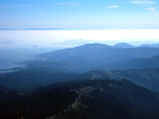
http://lh4.ggpht.com/_kysZWXKiMaU/R4CPUsdB-kI/AAAAAAAAC9U/iCCNMiYyhFY/20080101_New+Year%27s+Day+Hike_02x.jpg
Panoramic Highway view of San Francisco
There is no place to pass anywhere, but with luck you won't be stuck behind a road boulder, since traffic is light. Enjoy the scenery which is spectacular after the morning fog dissipates. The pavement can be rough in some parts, so proceed carefully.
Aug RD1
Panoramic Highway reconnects with Highway 1 at Stinson Beach, where you can stop and enjoy the beaches of clean sand; load up on coffee and groceries, but not on gas.
http://www.visitusa.com/california/images/beach-photos/marin-county/stinson-beach/stinsonbeach-view.jpg
View of Stinson Beach
Past Stinson Beach, the road follows the edge of the Bolinas Lagoon. Pull over and take a look at the beautiful waters and the birds. If you brought your fishing rod along, this is a great spot to tickle the fish. Visibility is decent, the pavement is good and the curves are predictable, but don't go too fast, as the consequences may be dear. The young man in the picture below found out the hard way. Everyone was fine, but the car was not.
Aug RD2
When the Bolinas Lagoon disappears in your rearview mirror, you enter the Olema Valley and are treated to 10 miles of clean pavement through the Point Reyes National Seashore. Speed through this area is fairly good but the scenery is worth slowing down for. Forested sections and sharp turns alternate with long straights along grassy pastures. Going through the town of Dogtown, population 30, you will see neither dog nor human. Maybe they will be back by the time you get there. Take a look at the map above. The Olema Valley - from Stinson Beach to Point Reyes Station -- and Tomales Bay to the north make a nice straight line that marks the San Andreas Fault. Point Reyes is moving north at the rate of about an inch and a quarter per year. Come back in a few million years, and Bolinas will be in Canada. In Olema, keep going straight on Highway 1, unless you are tired already and want to head back to San Rafael on Sir Francis Drake Boulevard. The next town is Point Reyes Station. As the murals on the wall of the post office depict, it was once a stop on the North Pacific Coast Railroad. However, don't expect a romantic steam ride; the last train came here in 1933. Cheda's Garage at the southern end of town is the oldest AAA establishment in California. The town is full of restaurants patronized on week-ends by bicyclists, motorcyclists and locals alike.
Aug RD3
One notable feature at the north end of town is the only stretch of road that features both a dashed yellow line and proper visibility. Make good use of it as needed. Continuing north, Highway 1 winds its way between Tomales Bay on the left and dairy farms on the right. In season you can stop and buy oysters in Marshall, population 50, fresh from the boat that brought them in. Oysters are best between October and February; try a cold Marlborough County Sauvignon Blanc from New Zealand with them. Between Marshall and Tomales, the pavement is pure bliss. The road turns east along Keyes Creek and arrives in Tomales at mile 46. Tomales is another small village, former home of Coast Miwok people, and most notable today for its collection of century old buildings. Nothing too stuffy though, you will even find a bit of that Marin County eclectic we all love. The William Tell House features an English telephone booth and an Italian menu. Go figure. The bakery at the intersection of 1st Street has good pastries and coffee. Across the highway, the Continental Inn has nine guest rooms. Plan on staying a while.
Aug RD4

Sunday, August 3, 2008

Reach Driving Nirvana in the Month of August

One woman's quest to bring automotive enthusiasts together on a group drive world wide. Can she do it?

read more | digg story

Sunday, July 13, 2008

Driving Nirvana

Awesome road
Stewarts Skaggs Point Spring Road and Hwy 1
A more complete route suggestion
Great Twisties 34 miles of the best road you'll ever come across on Stewarts Skaggs Point Spring Road. Very few driveways or X-roads, and you probably won't see more than a handful other vehicles.
Remember when driving was actually fun? When you'd get in the car and go somewhere just to explore? Every once in a while we enthusiasts have to remind ourselves that our cars are more than just a way to get to work and bring home groceries, no matter what the depressing set of digits on the gas pump says. When it's time to blow the cobwebs off your brain and some carbon off the valves, there's no substitute for a great driving road. For some, that road is a physical and mental workout. For others, it's a peaceful backdrop. Either way, we all have that special road that washes the soul clean and makes climbing behind the wheel for tomorrow's hour-long commute manageable.
The classic distinction between journey and destination, as the end-point is the ever-present view running parallel to the car.
While they may be ominous for less-seasoned drivers, tortuous byways are part of the allure for many coastal motorists. Kurt Fischer, president of Porsche Club of America's Redwood Region, based in Santa Rosa, says the Stewarts Point-Skaggs Creek road presents nearly 200 turns as it winds 35 miles through vineyards, valleys, mountains and streams toward the stunning coastline of Highway 1 near Bodega Bay. This is perfect terrain for the Porsche, Fisher says, "Any model will do, from the oldest 356 to the newest 997. The suspension, motor, transmission-the Porsche was designed for roads like these." LINK FOR MAP Suggested place to stay Video - Cliff Cove Chalet - Jenner, California

Sunday, June 22, 2008

World oil reserves quickly depleting?

Keeping up with the growing requirements for oil in 1st and emerging economies is straining every facet of the oil industry. Add to that, we are running out! read more digg story

Thursday, June 19, 2008

California new law approaching July 1st

Not only is talking hands-free on your wireless phone a good idea for safe driving, starting July 1st, 2008 – if you’re 18 or older – California law requires it.* With this new law fast approaching, now’s the perfect time to pick up a hands-free accessory. Follow the law all the way to your local AT&T store today. (California Vehicle Code Section 23123) We know you love your mobile phone. You call your friends, family, and business associates from everywhere: at the store, at the beach, in the shower. Okay…maybe not the shower? Well, starting on July 1, 2008, if you talk on your phone while you’re driving, you’ll need to use a hands-free listening and speaking system. Drivers cited will be subject to a fine of $20 (at least $70 with fees and penalties) for a first offense and $50 (at least $175 with fees and penalties) for subsequent offenses. Push to talk (PTT) systems, such as those from Nextel, will be exempt from the hands-free edict until July 1, 2011. California Driving Handbook & Auto Information California Driving: Road Rules & Driving Laws

Wednesday, June 18, 2008

Pacific Coast Hwy 1 tour to Morro Bay


Big Sur, California"The Greatest Meeting of Land and Sea" Down Hwy 1 - now where are the Porsches?
Tour details: Here are the details: meet in San Jose (off Hwy 101 & Hwy 85 - Bernal Road exit see below for more details) and caravan down to Monterey/Carmel area and down Pacific Coast Hwy 1. The directions to this route are pretty straight forward since it stays on one road, highway 1, the whole time.

The route is part of a stretch of Route One that was voted to be one of the "10 Best Drives" by the members of USAA insurance in 99 and made the list of 120 road trips highlighted in the Reader's Digest book "The Most Scenic Drives In America" Along this route you will see coastal scenery that will leave you breathless. Opposite the ocean, inland scenery is as inspiring with its display of rolling hills, rock outcroppings, picturesque waterfalls, redwood forests, flowered meadows, lush valleys, and majestic coastal mountains. Along the route you will see a number of light houses, 18th century Spanish missions, and a variety of animal life including sea lions, sea otters, sharks, bat rays, gray whales, brown pelicans, and peregrine falcons as well as monarch butterfly winter sanctuaries.

Lunch stop @ Nepehente Restaurant in Big Sur! Or stop for picnic lunch at Mill Creek Park.

Perched 800ft above the Pacific on a rocky promontory, Nepenthe Restaurant has the second-best view on the Big Sur coast.
Nepenthe Restaurant, Big Sur, CA

See this Nepenthe Live Cam during daytime for great view: click image for larger view Check out today's view South from Nepenthe's back verandah Nepenthe's Verandah is like the prow of a ship. From this deck, visitors can enjoy a view of the early morning sunrise over the Santa Lucia Mountain Range, a relaxing afternoon, an intimate evening or a spectacular sunset over the Pacific Ocean. While there can be a wait for this small deck, it is always worth it.

Cross the Bixby Bridge You will also cross the much photographed Bixby Bridge (you've probably seen this bridge in a few movies, postcards or TV commercials). It arches 256 feet above the meeting of the Bixby Creek and Pacific ocean. Just south of Bixby Bridge, the Point Sur Lighthouse stands atop a 360ft-high volcanic rock rising straight out of the surf. In continuous operation from 1899 to 1974, today it’s part of a state historic park that you can visit only by guided tour (reservations not accepted).


Friday, June 13, 2008

Coastal Overlooks

Run to the Coast
You can’t beat the San Mateo Coast for verdant springtime splendor—and you can do it in an afternoon. Rolling hills rise from the craggy coast, covered with different species of grass that create a patchwork of subtly different hues.

run to the coast 8

From San Francisco: 60 minutes to San Gregorio, via I-280 south to Hwy 1 south in Pacifica.
Chase the margin of green along the old stagecoach route,
from San Gregorio to Pescadero.
Then continue south along Cloverdale Rd,

cloverdale road 1

past picturesque horse farms lined with white split-rail fences. At Gazos Creek Rd, turn right to Hwy 1 north.
Travel time from SF: 60 minutes to San Gregorio, via I-280 south to Hwy 1 south in Pacifica.

coast run 2

What to See: The Pigeon Point Lighthouse, on your return trip north up Hwy 1.
Where to Eat:
Duarte’s Tavern, a country-Americana roadhouse in Pescadero. More information
Where to Pack a Picnic: The San Gregorio Store, a frozen-in-time 19th-century general store.
San Mateo Coast Beaches The San Mateo coast beaches are some of Northern California’s most majestic. Come on a weekday and you’ll have the sand to yourself. Get there early—before 10am—to claim a grill at one of the picnic areas, or sleep late and bring your own self-contained Weber. The beaches are strung together like pearls on a strand, don’t assume all the county’s beaches are alike. Far from it. Each has its own flavor and amenities. Bean Hollow State Beach, is the only dog-friendly beach this side of Half Moon Bay. Here’s a rundown of favorites. When the beach is not in your plans, you can watch hang gliders take their lives into their own hands at Fort Funston on your start or return of your road trip.

Tuesday, June 3, 2008

Patterson Via Mt. Hamilton

Mt. Hamilton from Patterson
Another trip via Mt. Hamilton from Patterson. From Porsche Club of America
As you exit Interstate 5, go west and immediately turn right onto Del Puerto Canyon Road. Further west, the canyon narrows sharply, the curves tighten and second gear is often required. As the road climbs, the pavement is not in very good shape, but the quality improves once you reach the Santa Clara County line. At The Junction, you could turn right and go back to Livermore, 31 miles away, but it's more fun to turn left onto San Antonio Valley Road towards San Jose.After a short rest, keep going west toward San Jose on Mount Hamilton Road. More tight and twisty stuff, all downhill. The road is quite narrow, and unfortunately the pavement is in fairly bad shape, so take it easy. It can get crowded on the weekends. Enjoy the view if you can, and practice heel and toeing on the down shifts.

Driving Tours

Driving Tours
Have a destination in mind ......? click on photo

Maps & Information

Useful Information

BAY AREA WEATHER FORECASTS:
Bay Area Weather

ACCUWEATHER CHANNEL up to date weather video:
Weather Channel

CALIFORNIA WEATHER WEBCAMS
Weather Webcam

CALIFORNIA AUTO NEWS & EVENTS WEBSITE
We Drive California

I have added great information on specific drives on Facebook.
Access the library on "Posted Items" of assorted drives/tours for the ideal trip best suited for the occasion.
Facebook
Enjoy!

For Vistors to Northern California
Northern California Road Trip - Muir Woods, Redwood, Lassen and more!
Northern California Visitor Information

Start and end in San Francisco. Mileage does not include sightseeing. Take a journey that explores National Parks, Monuments, National Seashores and more! This road trip also includes Lake Tahoe and a beautiful drive along the coast. You may want to extend the time to visit the numerous state parks and tourist areas.

Approximate Mileage/Time: 1300 miles, 12 days

More Porsche destinations will follow. Stay Tuned!


Twitter Updates

    follow me on Twitter

    Be sure to check back often for more backroad destinations!

    Pack up the car and enjoy California backroads through the breathtaking mountains, spectacular valleys, rugged coastlines, and dry desert plains of the Golden State. Have fun exploring California’s best scenic byways and back roads.


    NetworkedBlog